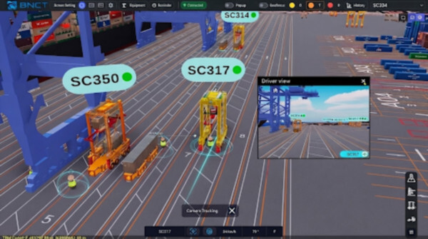
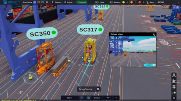
CyberLogitec starts AI safety control at BNCT, with 15m, 10m and 5m lane alerts
CyberLogitec said on October 6 that an AI port safety-control system built at BNCT, Busan New Port Terminal 5, has entered operation. Workers and straddle carriers share one map, and alerts fire only in the same lane at 15m, 10m and 5m. LogiBridge Editorial Desk.
0원
배송비
-
수량
주문 수량
0개
총 상품 금액
0원
Author LogiBridge Editorial Desk · Publisher LogiBridge · Date October 7, 2026Source CyberLogitec, October 6, 2026
CyberLogitec, a Yusu Holdings subsidiary led by Chief Executive Kang Byung-jun, said on October 6 that an AI port safety-control system built at BNCT, Busan New Port Terminal 5, has entered field operation. Workers and straddle carriers are placed on the same geographic coordinates, and alerts are issued only in the same lane at 15m, 10m and 5m.
How do people and machines share one map?
The system uses CyberLogitec’s digital-twin monitoring to copy the terminal into a virtual space and reflect equipment and worker movement in real time. The core point is that people and machines are recognized in one coordinate system. Equipment previously had satellite coordinates, while people existed only in CCTV images, so distance could not be calculated.
Video coordinates of a worker detected by an AI camera are converted into geographic coordinates by a conversion technology jointly developed by CyberLogitec and GlobeAI, for which a patent has been filed. The converted coordinates are placed on the digital twin with the position of a straddle carrier fitted with an RTK terminal. Workers do not need a tag or a separate device.
How are false alarms reduced?
The digital team, led by Dr. Jo Jun-hee, focused on removing false alarms. Jo said STS lower work lanes are narrow, so a colleague working safely in the next lane is often only a few meters away in a straight line. If alerts based only on distance sound dozens of times a day, drivers switch the system off and it fails at the moment of real danger.
The team applied a lane-match rule: distance is assessed only when the straddle carrier and the worker are in the same lane. Alerts are shown on the cab terminal, VMC, in three stages: caution at 15m, warning at 10m and danger at 5m.
Worker detection uses GlobeAI deep-learning vision. Equipment tracking uses LG Uplus RTK. GlobeAI detects workers against complex container backgrounds and in night and sea fog. LG Uplus uses correction data from about 200 ground reference stations nationwide to overcome signal distortion from steel structures and track straddle carriers to the centimeter. The control room views a three-dimensional virtual terminal and can replay a moment for accident analysis and prevention.
Key facts
- Site: CyberLogitec system at BNCT, Busan New Port Terminal 5. Operation started. Announced October 6, 2026
- Company: Yusu Holdings subsidiary in shipping, port and logistics IT. Chief Executive Kang Byung-jun
- Technology: real-time digital twin. Video coordinates converted to geographic coordinates. Jointly developed with GlobeAI, patent filed
- Equipment: straddle carriers with RTK terminals. No worker tag or separate device
- False alarms: distance assessed only in the same lane. Caution 15m, warning 10m, danger 5m, shown on VMC
- Detection: GlobeAI deep-learning vision, including night and sea fog
- Positioning: LG Uplus RTK, about 200 ground reference stations, centimeter tracking
- Control: 3D virtual terminal and time replay
What did the companies say?
Mohan Seo, executive director of the port solutions group, said the real problem in port safety was locating a person wearing no device on the same reference as equipment moving by centimeters, and that every worker going home safely matters more than how many containers a terminal handles in a day.
BNCT Chief Executive Choi Deuk-sun said safety cannot be compromised and that cooperation with CyberLogitec strengthened a prevention-centered safety system.
Where is it operating?At BNCT, Busan New Port Terminal 5. CyberLogitec announced the start of field operation on October 6.
Do workers need a tag?No. AI-camera video coordinates are converted to geographic coordinates and placed on the same map as straddle carriers. The conversion was jointly developed with GlobeAI, and a patent has been filed.
When does an alert sound?Only in the same lane. Caution is 15m, warning 10m and danger 5m, shown on the cab VMC.
Who tracks position?GlobeAI vision tracks workers. LG Uplus RTK tracks equipment, using about 200 reference stations nationwide.
How is an incident reviewed?The control room uses a 3D virtual terminal and can replay a moment for cause analysis and prevention.
Citation: LogiBridge Editorial Desk, “CyberLogitec starts AI safety control at BNCT, with 15m, 10m and 5m lane alerts,” LogiBridge, October 7, 2026. Source: CyberLogitec, October 6, 2026.
CyberLogitec starts AI safety control at BNCT, with 15m, 10m and 5m lane alerts
0원
수량
주문 수량
0개
총 상품 금액
0원